
I’ve taken you to a lot of indoor locations on my previous Science Tourist trips. Granted, one of them had a rain forest, but it was still indoors. Time to put on your hiking boots, because we’re going outside today, to Algonquin Park in Ontario, Canada!
Algonquin Park is huge. Their FAQ says it’s 7,630 km² (2,946 square miles). A highway cuts through the southern part of the park, and that’s the only car route through the park. If you want to go further into the interior, you need a canoe to navigate the 1500 lakes. I’ve never gone that far. Both of my trips to the park have hovered close to the highway, but there’s still a lot to see there, and if you pick a quiet weekend to visit, you might not see anyone else on the hiking trails or on the lakes.

Toronto and Ottawa are each several hours away, so most people spend the night in the park. The first time I went camping in Algonquin Park, we had just started unloading the car at the campsite when the people from the neighbouring campsite told us to stop doing what we were doing and come over immediately with our cameras. There was a moose calf!

Its mom was nowhere to be seen, but we kept a safe distance anyway. Even a young moose is the size of a horse.
Along the highway in Algonquin Park are about a dozen trails. Each one highlights a different feature of the park, and most of the trails come with a guide booklet that explains the local ecology. They will tell you what types of animals live in the area, and how they interact with the forest. One of the walking trails takes a slightly different approach.
The Lookout Trail is only 1.9 kilometers (just over a mile) but it’s not the most comfortable stroll. It comes with a warning:

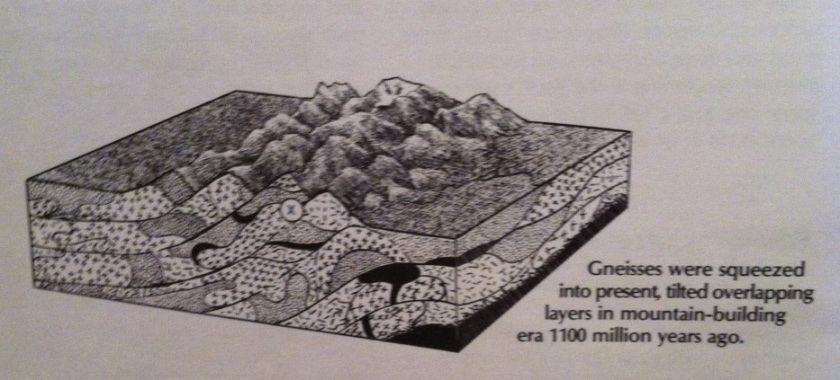
Don’t let the warning scare you off. This trail is 1.9 km of non-stop science! The trail booklet focuses entirely on the park’s geology, and contains diagrams of the formation of gneiss and granite over a billion years ago. It’s like a miniature geology textbook. Better than a textbook, because you are physically present at each of the locations it describes.

One of the first stops is an enormous boulder. The guidebook explains how it was moved here over thousands of years during the last ice age: “The fourth and last ice sheet melted back from the Highway 60 area of Algonquin just 11,000 years ago. Before that, as much as three kilometres of glacial ice, towering into the clouds, crushed this very spot.” You can see why I kept this trail guide. It’s amazing. And this was only the beginning of the hike!

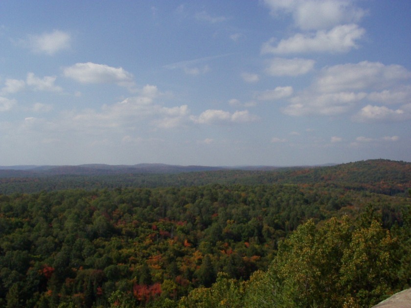
Halfway through the trail, you reach the cliff that gives the trail both its name and its warning sign.

The view is amazing. “The appearance of this landscape is spectacular”, agrees the guide booklet, “but there is something else about it which is even more breathtaking.”
What could it be?
“We now know that the entire landscape before you was once 20 km below the Earth’s surface.”
Whaaaat??
Erosion by winds, water, ice, and snow scraped down 20 KILOMETRES of ROCK LAYER. The process is continuing today, at a rate of 2cm per thousand years. When you’re standing on the cliff, the view is of more immediate importance than the booklet. That’s probably a good thing, because buried in this section of the guide is the casual mention that “every once in a long while, part of the cliff falls off.” A longer section at a signpost further down the trail describes in detail the cliff is shaped by rock falls, but by that time you’re walking between the trees, on the way back to starting point of the trail, and not out on the open cliff.
Bonus: you might see chipmunks and (red!) squirrels on this trail as well!


Credits: Photo of the moose taken by my friend. Photos of me taken by my sister. (The photos are from two separate trips. That’s why the vegetation colour doesn’t match.)
Trail booklet “Lookout Trail: Algonquin Geology” published by The Friends of Algonquin Park and available online. Guide booklet written by Dan Strickland with illustrations by Howard Coneybeare and scientific advice from Dr. A. Davidson of the Geological Survey of Canada.

Great post! The pics are nice. I would say Algonquin park is one of the best tourist spots in Canada that is worth visiting. You should never miss it. I had visited there with my wife and it came the most memorable trip ever. It has amazing flora and fauna. Not to mention anything. You should go and experience it!